Weather
Tornado Watch Issued for Parts of Louisiana, Arkansas, and Mississippi
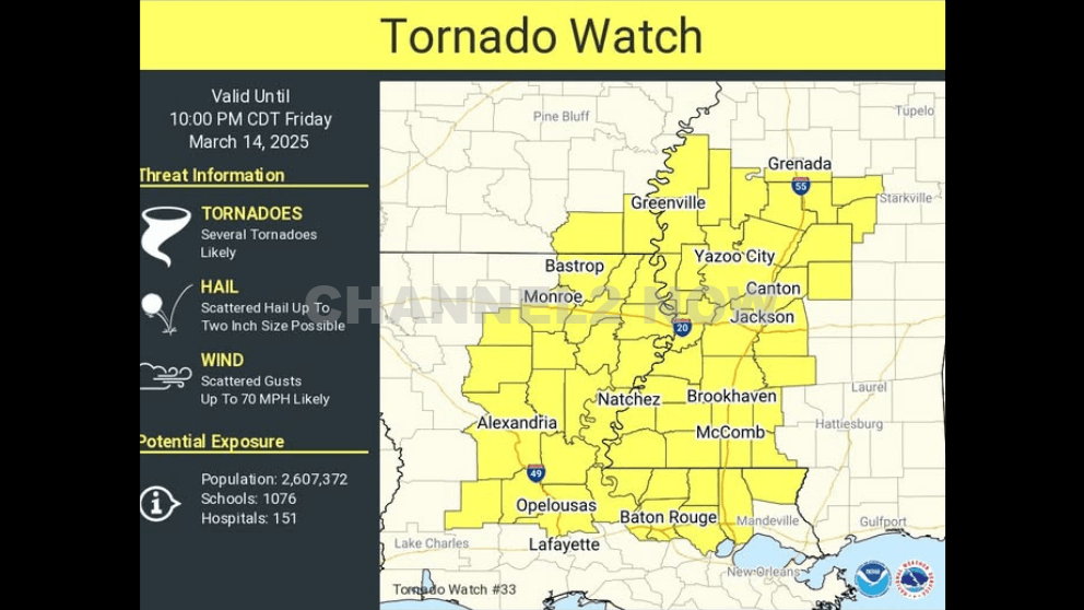
The National Weather Service (NWS) Storm Prediction Center has issued a Tornado Watch for portions of southeastern Arkansas, eastern and northeastern Louisiana, and western and southwestern Mississippi.
The watch is in effect from 5:00 PM until 10:00 PM CDT as conditions are highly favorable for severe weather, including tornadoes, large hail, and damaging wind gusts.
Affected Areas
In central Louisiana, the following parishes are included in the watch:
- Rapides
- Grant
- Allen
- Evangeline
- St. Landry
- Avoyelles
- LaSalle
- Catahoula
- Winn
- Concordia
Primary Threats
- Several tornadoes are possible, including the potential for strong and intense (EF2+) tornadoes.
- Scattered damaging wind gusts of up to 70 mph are likely.
- Scattered large hail is expected, with isolated instances of very large hail up to 2 inches in diameter possible.
Thunderstorm development is anticipated this afternoon and evening within a highly unstable and strongly sheared atmospheric environment across the Lower Mississippi Valley.
Given these conditions, supercell thunderstorms capable of producing all severe weather hazards, including large hail and strong tornadoes, are expected to develop.
The Tornado Watch covers an area approximately 65 miles east and west of a line extending from 65 miles south-southeast of Alexandria, LA, to 25 miles northwest of Greenwood, MS.
Residents in the affected areas should closely monitor weather alerts and have a severe weather safety plan in place.
Stay informed through official weather sources, including the National Weather Service, local emergency management, and NOAA Weather Radio. Additional warnings may be issued as the situation develops.