
Weather
Woman and her 7-year-old daughter died in Hart County flash flooding, child identified


HART COUNTY, KY – A woman Amy Philpott and her 7-year-old child, Charlotte Philpott, tragically lost their lives after their vehicle was swept away by flash flooding in the Bonnieville community of Hart County on Saturday night, authorities confirmed.
According to Hart County Coroner Tony Roberts, emergency responders from Campbellsville and Hart County were dispatched to Campground Road near Bacon Creek following reports of a water rescue.


Despite their best efforts, rising floodwaters and hazardous nighttime conditions forced crews to halt rescue operations before they could safely retrieve the victims and their vehicle.
Rescue teams recovered the child’s body from the submerged vehicle late Saturday night, but efforts to locate the mother had to be suspended until conditions improved.
On Sunday morning, search teams resumed recovery efforts and successfully retrieved the mother’s body later in the day.
The National Weather Service (NWS) in Louisville reported that the tragic incident occurred around 10:30 p.m. Saturday, when the victims’ vehicle was overtaken by rapidly rising floodwaters.
The devastating floods have wreaked havoc across Kentucky, triggering over 1,000 rescues as emergency teams race to assist those stranded by rising waters.
At least eight fatalities have been confirmed so far, with officials warning that the death toll may rise as search-and-rescue efforts continue.
“This is one of the most serious weather events we’ve dealt with in at least a decade,” Kentucky Governor Andy Beshear stated on Sunday.
Victims have been reported in Hart, Pike, and Clay counties, with many fatalities involving vehicles caught in floodwaters. Gov. Beshear urged residents to avoid driving in flooded areas to prevent further loss of life.
In Clay County, officials confirmed that a 73-year-old man was found dead in floodwaters, according to Revelle Berry, Deputy Director of County Emergency Management.
Widespread Impact Across the State
- Nearly 40,000 residents remain without power.
- 9,800 service connections are currently without water.
- 26,000 residents are under a boil-water advisory.
- Pike County School District announced indefinite school closures due to the disaster.
On Sunday, Gov. Beshear announced that President Donald Trump had approved his request for federal disaster relief funding to assist impacted communities.
Parts of Kentucky and Tennessee were inundated with up to six inches of rainfall over the weekend, according to Bob Oravec, senior forecaster at the National Weather Service.
“The effects will continue for a while—a lot of swollen streams and a lot of flooding still happening,” Oravec warned. “Even when the rain stops, floodwaters can linger for much longer.”
In addition to the devastation in Kentucky, officials confirmed that a levee in Rives, Tennessee, failed Saturday afternoon, flooding nearby neighborhoods. The extent of the impact remains unclear, and authorities are continuing to assess the damage.
Authorities are urging residents to remain cautious, avoid flooded roads, and follow local emergency guidelines as rescue and recovery efforts continue.












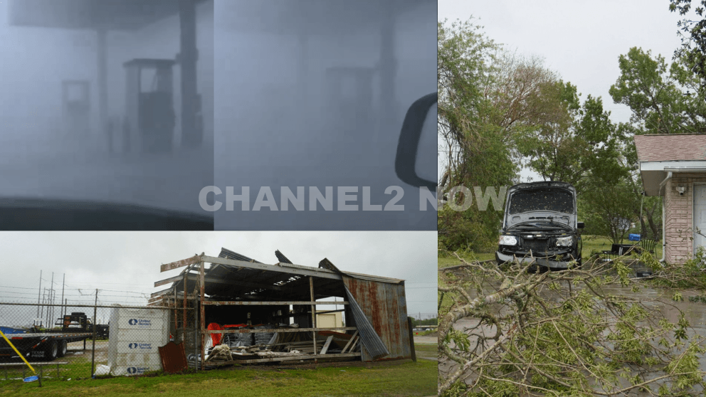
POINT COMFORT, Texas — Powerful thunderstorms swept across parts of the Texas Gulf Coast, producing extreme wind gusts that caused significant destruction in Point Comfort and surrounding areas, according to the National Weather Service (NWS).
A WeatherFlow HurrNet station recorded a peak wind gust of 119 miles per hour in Point Comfort, indicating a highly destructive wind event—likely a downburst associated with a line of severe thunderstorms that moved through the region.
Nearby communities also experienced intense conditions, with wind gusts reaching 77 mph in Palacios, Texas.
Widespread Storm Damage Reported
Preliminary reports indicate extensive damage stretching from near Coleto Creek Reservoir southeast through Point Comfort and toward Port O’Connor.
Residents and storm observers described scenes of severe impact consistent with extreme straight-line winds.
Reported damage includes:
- Downed power lines and widespread power outages across Point Comfort
- Large transmission towers toppled or severely damaged
- Trees uprooted or snapped at the base, with some falling onto homes
- Metal structures and roofing materials torn from buildings
- Vehicles, including trucks and boats, overturned by strong winds
- Billboards destroyed and outdoor infrastructure heavily damaged
One eyewitness described winds “easily exceeding 100 mph,” noting that debris, including large pieces of metal, was ripped from nearby buildings.
Additional reports suggest that a semi-truck parked at an industrial site was flipped, further underscoring the intensity of the wind event.
Possible Downburst Under Investigation
Meteorologists believe the damage pattern is consistent with a downburst, a powerful column of sinking air that spreads outward upon reaching the ground, producing intense and localized wind damage.
However, the National Weather Service has confirmed that a formal damage survey will be conducted to determine the exact cause.
Community Urged to Share Information
Officials are asking residents to submit photos, videos, and damage reports, including locations and estimated times, to assist with the ongoing assessment.
This information will help meteorologists better understand the storm’s impact and confirm whether the event was solely caused by straight-line winds or involved additional severe weather factors.
Ongoing Recovery Efforts
Emergency crews and utility workers are actively responding to restore power and clear debris as residents begin recovery efforts.
Authorities continue to urge caution in affected areas due to downed lines, unstable structures, and hazardous debris.
This severe weather event highlights the destructive potential of fast-moving thunderstorm systems and the importance of staying alert during rapidly changing weather conditions.