
Weather
Mid-March 2025 Storm Complex: Fatality Toll Rises to 17 as Tornadoes Devastate the Midwest and South
As the aftermath of a violent storm system unfolds, authorities have confirmed 17 fatalities across multiple states due to a destructive tornado outbreak that tore through Missouri, Arkansas, and Texas.
Fatality Breakdown by State
- Missouri – 10 fatalities
- 6 in Wayne County
- 2 in Ozark County
- 1 in Butler County
- 1 in Jefferson County
- Texas – 4 fatalities
- 2 in Gray County
- 2 in Palmer County
- Arkansas – 3 fatalities
- 3 in Independence County
This marks the deadliest tornado event in Missouri since the catastrophic 2011 Joplin tornado that claimed 161 lives.
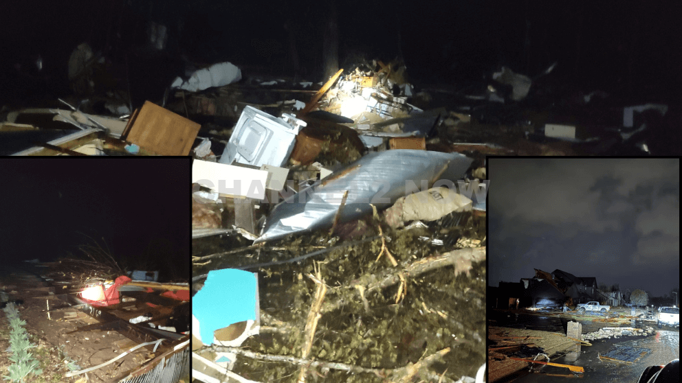
The widespread severe weather outbreak began Friday evening, unleashing numerous tornadoes across multiple states, causing significant damage and injuries.
Missouri bore the brunt of the devastation, with the Missouri State Highway Patrol confirming the highest casualty count in Wayne County, followed by other affected regions including Ozark, Butler, and Jefferson counties.
In Arkansas, the Arkansas Division of Emergency Management reported three fatalities in Independence County and 29 injuries across eight counties as the storm swept through.
Villa Ridge, Missouri, located outside St. Louis, witnessed a violent tornado that was caught on camera.
The storm’s powerful winds triggered numerous power flashes, overturned semi-trucks, and caused structural damage.
Other Missouri communities, such as Rolla, Hartville, and areas near St. Louis, also reported confirmed tornado touchdowns.
In Cave City, Arkansas, at least five people sustained injuries when a tornado tore through the area.
Mayor Jonas Anderson, who declared a state of emergency, expressed gratitude that no fatalities were reported, calling it “an absolute miracle.”
In Gibson County, Indiana, a powerful tornado struck Oakland City and the rural Francisco area, leaving a path of destruction.
Sheriff Bruce Vanoven urged residents to stay away from damaged areas, emphasizing the danger posed by downed power lines and debris.
A dramatic video from Rolla, Missouri, captured two men encountering a tornado while at a gas station. As violent winds and debris battered their truck, they narrowly escaped unharmed.
FindEnergy.com reported that the storm system left nearly 250,000 customers without power, spanning from the Midwest to the lower Mississippi River Valley.
In response to the outages, emergency management agencies have opened shelters and charging stations to assist affected residents.
The Severe Storm Prediction Center (SPC) issued over 150 tornado warnings as the system tracked eastward.
A “Particularly Dangerous Situation” (PDS) Tornado Watch was declared for multiple states, signaling the likelihood of multiple violent tornadoes.
Meteorologists warn that Saturday could be even more dangerous, as the powerful storm system moves into the Gulf Coast and Deep South, placing 3.3 million people at risk in cities such as Birmingham, Jackson, Tuscaloosa, and Hattiesburg.
“This will be a very scary situation for many,” warned NWS Birmingham meteorologists, emphasizing that the storm’s intensity is unlikely to weaken.
Residents in the storm’s path are urged to stay weather-aware, have a safety plan, and heed all emergency warnings.
Authorities continue to assess damage, conduct search and rescue operations, and monitor the evolving situation.
Further updates will be provided as new information becomes available.


BLOOMINGTON, Ind. — Emergency responders are working multiple rescue calls after a confirmed tornado touched down west of Bloomington and moved directly toward the city, prompting urgent shelter warnings across the region.
The National Weather Service issued a Tornado Warning for Bloomington, Ellettsville, and Clear Creek until 7:30 p.m. EST, describing the situation as particularly dangerous.
The tornado was confirmed on the ground approximately eight miles west of Bloomington and moving east at an estimated 40 miles per hour.
Authorities report that multiple homes have sustained significant damage, with early indications that several individuals may be trapped inside residences impacted by the storm.
Emergency crews are actively conducting search and rescue operations in affected neighborhoods.
Communities directly in the projected path included Bloomington, Ellettsville, the campus of Indiana University Bloomington, Solsberry, and Whitehall.
Meteorologists warned that the storm was capable of producing destructive winds and hail up to the size of ping pong balls. Officials emphasized that the tornado posed a serious threat to life and property.
Residents in the warned area were urged to seek shelter immediately — preferably in a basement or on the lowest level of a sturdy structure, inside an interior room away from windows.
Authorities stressed not to delay action while waiting for visual confirmation of the tornado.
Emergency management officials continue to monitor the storm’s track and assess damage. Additional updates are expected as response efforts continue and more information becomes available.