
Weather
Sirens Wail Across Jamaica Old Harbour Bay as Powerful Hurricane Melissa Approaches Landfall

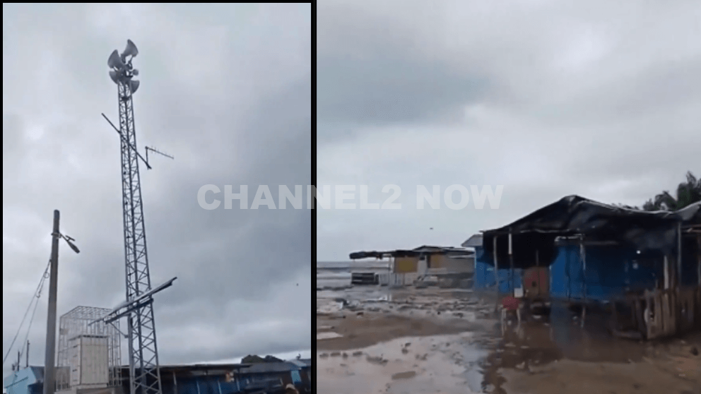
OLD HARBOUR BAY, JAMAICA — Emergency sirens are sounding across Jamaica’s southern coast as Hurricane Melissa, a powerful and rapidly intensifying Category 4 storm, bears down on the island.
The National Hurricane Center (NHC) warns that Melissa could strengthen further into a catastrophic Category 5 hurricane before making landfall late Monday night or early Tuesday morning.
In its 5 p.m. ET advisory on Sunday, the NHC confirmed that Melissa has resumed intensification, with satellite and reconnaissance data showing a small, well-defined eye and a highly organized inner core — indicators of a major hurricane gaining strength.
“Hurricane Melissa has intensified again,” the NHC stated. “Melissa could make landfall as a catastrophic Category 5 hurricane.”
As of the latest update, Melissa is producing maximum sustained winds of 145 mph (230 km/h) and is moving westward at 5 mph (8 km/h).
The storm’s center was located approximately 115 miles south-southwest of Kingston, Jamaica, with a central pressure of 941 millibars, suggesting continued strengthening in the hours ahead.
Forecasters warn that life-threatening storm surge, destructive hurricane-force winds, and torrential rainfall could cause catastrophic damage across large portions of Jamaica.
- Rainfall totals: Up to 40 inches (1,000 mm) in isolated areas.
- Storm surge: 9–13 feet possible along Jamaica’s southern coastline.
- Wind damage: Widespread structural damage and long-term power outages are expected.
- Flooding and landslides: Flash flooding and mudslides likely across mountainous terrain.
In a key message Sunday evening, the NHC urged immediate protective action:
“Seek shelter now. Extensive infrastructural damage, long-duration power and communication outages, and isolation of communities are expected.”
- Hurricane Warning: Entire island of Jamaica and four provinces in eastern Cuba, including Guantánamo.
- Tropical Storm Warning: Las Tunas Province, Cuba.
- Tropical Storm and Hurricane Watches: Southern Haiti, where conditions may deteriorate by late Monday.
Current projections show Melissa continuing westward before making a sharp northeastward turn toward southeastern Cuba late Tuesday.
The storm could make a second landfall in Cuba before crossing the southeastern Bahamas midweek, eventually moving back into the open Atlantic by Thursday.
If Melissa maintains its strength and current path, it could rank among the strongest hurricanes ever to make direct landfall in Jamaica.
Emergency officials in Jamaica are urging all residents to complete preparations immediately, secure property, and relocate to designated hurricane shelters. Authorities warn that rescue operations may be impossible during the peak of the storm due to dangerous conditions.
Residents in coastal and low-lying areas are being told to evacuate immediately as conditions in regions like Old Harbour Bay, Clarendon, and Kingston Parish rapidly deteriorate.
This is a developing situation. Further updates will be issued by the National Hurricane Center, the Jamaica Meteorological Service, and local emergency management agencies as Hurricane Melissa approaches landfall.



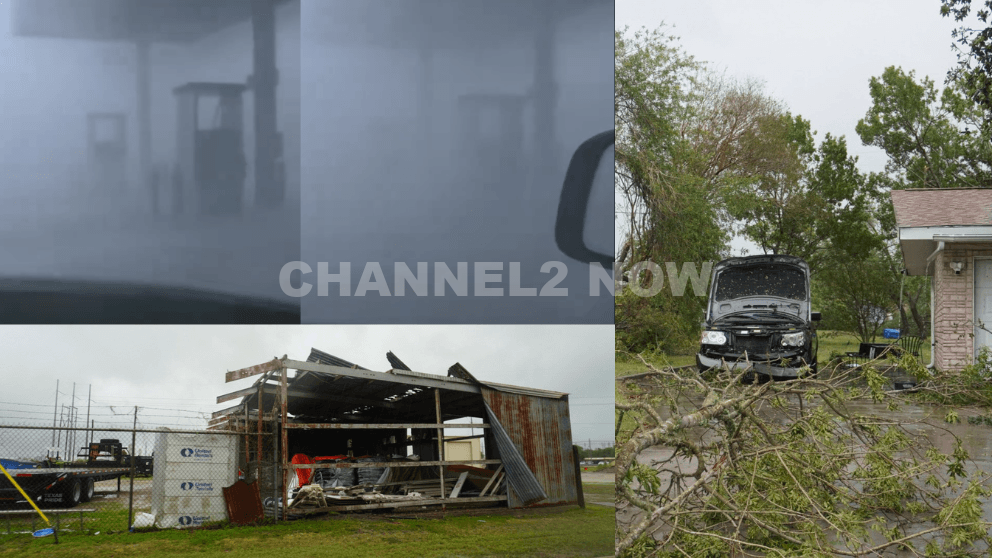
POINT COMFORT, Texas — Powerful thunderstorms swept across parts of the Texas Gulf Coast, producing extreme wind gusts that caused significant destruction in Point Comfort and surrounding areas, according to the National Weather Service (NWS).
A WeatherFlow HurrNet station recorded a peak wind gust of 119 miles per hour in Point Comfort, indicating a highly destructive wind event—likely a downburst associated with a line of severe thunderstorms that moved through the region.
Nearby communities also experienced intense conditions, with wind gusts reaching 77 mph in Palacios, Texas.
Widespread Storm Damage Reported
Preliminary reports indicate extensive damage stretching from near Coleto Creek Reservoir southeast through Point Comfort and toward Port O’Connor.
Residents and storm observers described scenes of severe impact consistent with extreme straight-line winds.
Reported damage includes:
- Downed power lines and widespread power outages across Point Comfort
- Large transmission towers toppled or severely damaged
- Trees uprooted or snapped at the base, with some falling onto homes
- Metal structures and roofing materials torn from buildings
- Vehicles, including trucks and boats, overturned by strong winds
- Billboards destroyed and outdoor infrastructure heavily damaged
One eyewitness described winds “easily exceeding 100 mph,” noting that debris, including large pieces of metal, was ripped from nearby buildings.
Additional reports suggest that a semi-truck parked at an industrial site was flipped, further underscoring the intensity of the wind event.
Possible Downburst Under Investigation
Meteorologists believe the damage pattern is consistent with a downburst, a powerful column of sinking air that spreads outward upon reaching the ground, producing intense and localized wind damage.
However, the National Weather Service has confirmed that a formal damage survey will be conducted to determine the exact cause.
Community Urged to Share Information
Officials are asking residents to submit photos, videos, and damage reports, including locations and estimated times, to assist with the ongoing assessment.
This information will help meteorologists better understand the storm’s impact and confirm whether the event was solely caused by straight-line winds or involved additional severe weather factors.
Ongoing Recovery Efforts
Emergency crews and utility workers are actively responding to restore power and clear debris as residents begin recovery efforts.
Authorities continue to urge caution in affected areas due to downed lines, unstable structures, and hazardous debris.
This severe weather event highlights the destructive potential of fast-moving thunderstorm systems and the importance of staying alert during rapidly changing weather conditions.