
Weather
Flash Flood Emergency declared for Little Rock, Arkansas
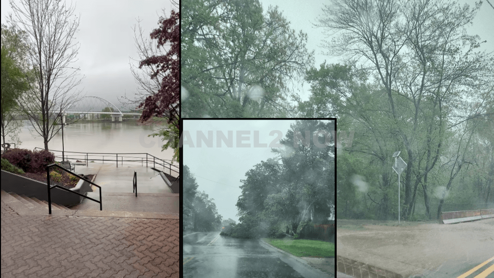
Life-Threatening Flooding Ongoing Across Central Arkansas
LITTLE ROCK, AR — A Flash Flood Emergency has been declared for the Little Rock metro area as a Particularly Dangerous Situation (PDS) continues to unfold across Central Arkansas.
The National Weather Service has issued an urgent warning as catastrophic flooding is either ongoing or imminent in areas including Little Rock, North Little Rock, Conway, Benton, Cabot, and Searcy.
Current Conditions
- Over 7 inches of rain have fallen in some areas today, with Little Rock alone receiving more than 4 inches in a matter of hours.
- Rain gauges across Central Arkansas are reporting between 6 to 10 inches of rainfall from this slow-moving, training line of thunderstorms.
- Up to 15 inches of rainfall is possible in isolated areas by Sunday, which will lead to life-threatening flash flooding and major river flooding.
Impacted Areas
- Low-lying neighborhoods, urban centers, and areas near rivers and creeks are experiencing rapid rises in water levels.
- Numerous flash flood incidents have already been reported, and more than 100 emergency calls related to high water have been logged.
- Major river flooding is expected along the Arkansas, White, and Spring Rivers, with some communities potentially reaching record crest levels.
Infrastructure Impact
- North Hills Boulevard has multiple trees down, including a large tree blocking both lanes in front of The Lakewood House.
- 5 Mile Creek is nearing overflow onto nearby roadways.
- Numerous roads are impassable due to high water, and vehicles have already become stranded.
Weather Threats
- While the severe weather threat has passed for Texarkana, Little River, Sevier, Howard, Pike, Hempstead, Miller, Polk, Montgomery, and Scott counties, flooding remains a major concern.
- Additional tropical downpours are likely, bringing the risk of renewed or worsening flash flooding.
- Areas east and south of Little Rock remain under threat for severe storms, including the potential for tornadoes, damaging winds, and large hail.
Public Safety Alerts & What You Must Do:
- DO NOT drive through flooded roads. It only takes six inches of moving water to knock you off your feet and less than two feet to carry away most vehicles.
- If you live near a river, creek, or low-lying area—prepare immediately. Move to higher ground if possible and secure valuables.
- Monitor official weather alerts closely. Follow instructions from local emergency management and the National Weather Service.
- Do not leave your home unless absolutely necessary. Emergency services are stretched thin, and rescue resources should not be diverted for avoidable situations.
This is a life-threatening emergency.
The term Flash Flood Emergency is reserved for only the most severe flooding scenarios. Please take this seriously, stay off the roads, and protect yourself and your family.
For real-time updates, tune in to local weather stations or follow the National Weather Service – Little Rock and Arkansas Division of Emergency Management on social media.


BLOOMINGTON, Ind. — Emergency responders are working multiple rescue calls after a confirmed tornado touched down west of Bloomington and moved directly toward the city, prompting urgent shelter warnings across the region.
The National Weather Service issued a Tornado Warning for Bloomington, Ellettsville, and Clear Creek until 7:30 p.m. EST, describing the situation as particularly dangerous.
The tornado was confirmed on the ground approximately eight miles west of Bloomington and moving east at an estimated 40 miles per hour.
Authorities report that multiple homes have sustained significant damage, with early indications that several individuals may be trapped inside residences impacted by the storm.
Emergency crews are actively conducting search and rescue operations in affected neighborhoods.
Communities directly in the projected path included Bloomington, Ellettsville, the campus of Indiana University Bloomington, Solsberry, and Whitehall.
Meteorologists warned that the storm was capable of producing destructive winds and hail up to the size of ping pong balls. Officials emphasized that the tornado posed a serious threat to life and property.
Residents in the warned area were urged to seek shelter immediately — preferably in a basement or on the lowest level of a sturdy structure, inside an interior room away from windows.
Authorities stressed not to delay action while waiting for visual confirmation of the tornado.
Emergency management officials continue to monitor the storm’s track and assess damage. Additional updates are expected as response efforts continue and more information becomes available.