
Weather
Tornado Causes Significant Damage in Princeton, No Injuries Reported
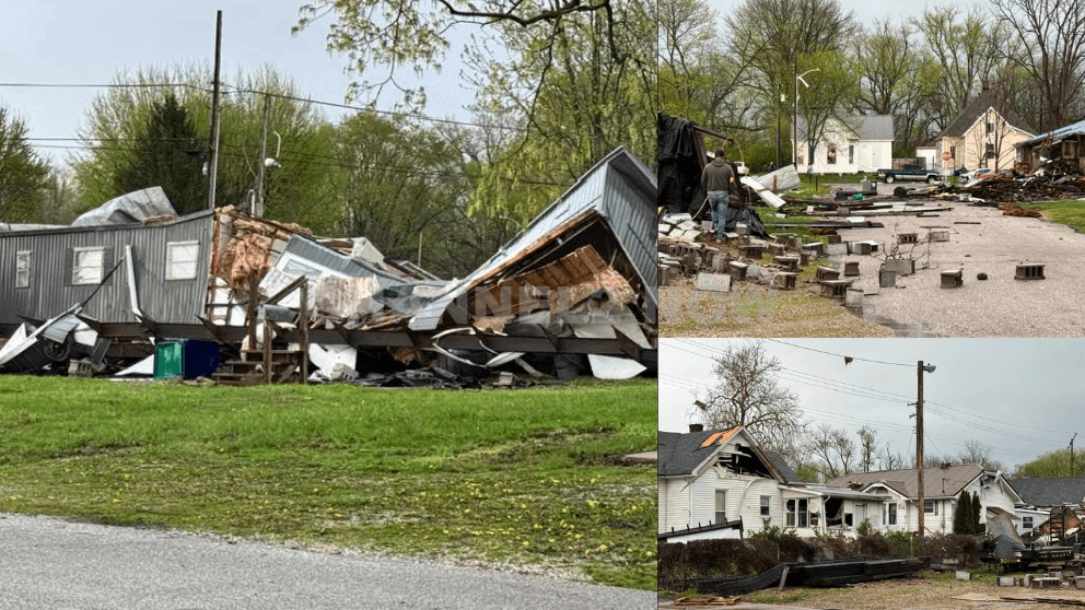
Emergency crews are responding to widespread storm damage in Princeton, Indiana after a tornado touched down in the area Thursday evening, leaving a trail of destruction across multiple neighborhoods.
According to the National Weather Service, a trained weather spotter confirmed a tornado in the area, reporting that the storm tore roofs off buildings and caused major structural damage.
The most heavily impacted area includes the vicinity of Seminary and Oak Streets, where multiple mobile homes sustained significant damage.
Officials on scene confirmed that power lines are down, contributing to hazardous conditions.
Residents are strongly urged to avoid the affected area, both for safety and to allow emergency personnel to conduct response and recovery operations.
Emergency management officials stated that, at this time, no injuries have been reported, and all residents in the damaged area have been accounted for.
The damage spans an estimated eight-block area, with visible destruction to homes, debris scattered across roads, and utility disruptions throughout the community.
Local authorities continue to assess the extent of the damage, and cleanup efforts are underway.
Further updates will be issued as more information becomes available.


BLOOMINGTON, Ind. — Emergency responders are working multiple rescue calls after a confirmed tornado touched down west of Bloomington and moved directly toward the city, prompting urgent shelter warnings across the region.
The National Weather Service issued a Tornado Warning for Bloomington, Ellettsville, and Clear Creek until 7:30 p.m. EST, describing the situation as particularly dangerous.
The tornado was confirmed on the ground approximately eight miles west of Bloomington and moving east at an estimated 40 miles per hour.
Authorities report that multiple homes have sustained significant damage, with early indications that several individuals may be trapped inside residences impacted by the storm.
Emergency crews are actively conducting search and rescue operations in affected neighborhoods.
Communities directly in the projected path included Bloomington, Ellettsville, the campus of Indiana University Bloomington, Solsberry, and Whitehall.
Meteorologists warned that the storm was capable of producing destructive winds and hail up to the size of ping pong balls. Officials emphasized that the tornado posed a serious threat to life and property.
Residents in the warned area were urged to seek shelter immediately — preferably in a basement or on the lowest level of a sturdy structure, inside an interior room away from windows.
Authorities stressed not to delay action while waiting for visual confirmation of the tornado.
Emergency management officials continue to monitor the storm’s track and assess damage. Additional updates are expected as response efforts continue and more information becomes available.