
Weather
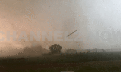
Large Tornado on the ground near Clear Lake, South Dakota
CLEAR LAKE, S.D. – A powerful and confirmed tornado touched down near Clear Lake, South Dakota, around 7:00 p.m. prompting urgent warnings and shelter advisories across the region.
Spotters and storm chasers reported at least two tornadoes on the ground in the area, including one between Altamont and Clear Lake in Deuel County.
The National Weather Service issued a Tornado Warning for Deuel and Hamlin Counties, in effect until 7:15 p.m. CDT. As of 6:56 p.m., a tornado was confirmed on the ground near Altamont, tracking eastward at approximately 20 miles per hour.
The storm is also producing ping-pong ball-sized hail.
Current Storm Details:
- Location: Between Altamont and Clear Lake
- Direction & Speed: Moving east at 20 mph
- Hazards: Observed tornado, large hail up to 1.5 inches in diameter
- Time of Last Confirmation: 6:56 p.m. CDT
- Coordinates: 44.81°N, 96.71°W
Areas Likely Impacted Around 7:00 p.m.:
- Clear Lake
- Altamont
- Lake Alice
- Tunerville
This is a dangerous and life-threatening situation. Flying debris poses a serious hazard to those caught outdoors or in mobile homes.
Extensive damage to roofs, windows, vehicles, and trees is likely. Residents are urged to take immediate action:
“To repeat, a tornado is on the ground. TAKE COVER NOW! Move to a basement or an interior room on the lowest floor of a sturdy building. Stay away from windows. If you are outside, in a mobile home, or in a vehicle, move to the nearest substantial shelter and protect yourself from flying debris.”
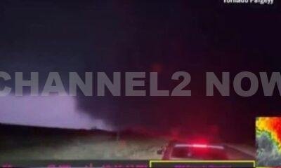
The tornado warning was reinforced by dramatic visual confirmation from storm chaser Alex Bartholomew, who captured a striking image of the tornado near Clear Lake, with fellow chaser Stephen Jones visible in the foreground of the scene.
Local authorities and emergency management officials continue to monitor the situation closely.
Additional updates will be provided as more information becomes available.
If you are in the affected area, do not delay — seek shelter immediately and monitor local alerts.


BLOOMINGTON, Ind. — Emergency responders are working multiple rescue calls after a confirmed tornado touched down west of Bloomington and moved directly toward the city, prompting urgent shelter warnings across the region.
The National Weather Service issued a Tornado Warning for Bloomington, Ellettsville, and Clear Creek until 7:30 p.m. EST, describing the situation as particularly dangerous.
The tornado was confirmed on the ground approximately eight miles west of Bloomington and moving east at an estimated 40 miles per hour.
Authorities report that multiple homes have sustained significant damage, with early indications that several individuals may be trapped inside residences impacted by the storm.
Emergency crews are actively conducting search and rescue operations in affected neighborhoods.
Communities directly in the projected path included Bloomington, Ellettsville, the campus of Indiana University Bloomington, Solsberry, and Whitehall.
Meteorologists warned that the storm was capable of producing destructive winds and hail up to the size of ping pong balls. Officials emphasized that the tornado posed a serious threat to life and property.
Residents in the warned area were urged to seek shelter immediately — preferably in a basement or on the lowest level of a sturdy structure, inside an interior room away from windows.
Authorities stressed not to delay action while waiting for visual confirmation of the tornado.
Emergency management officials continue to monitor the storm’s track and assess damage. Additional updates are expected as response efforts continue and more information becomes available.